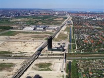
© Ole Malling
From 1947, the “Fingerplan”, the structural plan for the development of the area around Copenhagen, formed the basis of the city’s infrastructure planning. Until recently, in fact, it was the only development plan for the region as a whole. Little political interest was shown in any comprehensive urban planning programme. The one exception was the Ørestad area. Three million people live in this region, and with the new Metro City Line, the travelling time to the centre of Copenhagen is only three minutes. A master plan was drawn up for the area with the support of the Ørestad Development Corporation, which also produced a design handbook. Situated on the island of Amager between the old city centre of Copenhagen and the international airport, Ørestad covers an area of 310 hectares. With a length of 5 km and a width of 600 m, it extends from the university to the E45 motorway that links Malmö and Copenhagen. The urban development zone comprises the eastern districts of Vestamager and Amager, which belong in equal parts to the city of Copenhagen and the Danish state. The Ørestad Development Corporation is, therefore, made up of representatives of these two tiers of government. (Tanja Jordan)


